


seminars
13
Apr
2026
Science for Sustainable Development: Opportunities for the Next Genera...
Online
Back
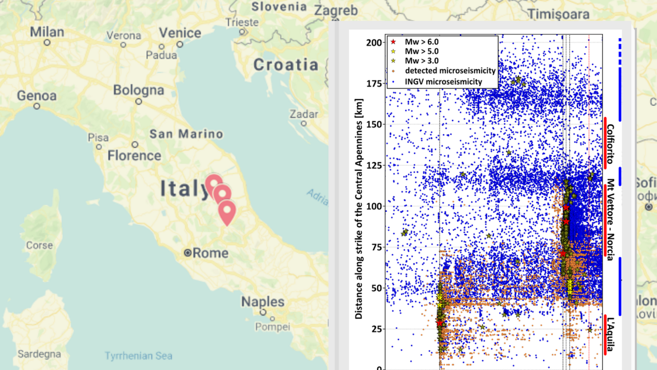
On 6 April 2009, the city of L’Aquila, in the central Italian region of Abruzzo, was shattered by a violent 6,3 magnitude earthquake. The earthquake caused the deaths of more than 300 people and plenty of structural damage. In the following months and years other seismic events took place along the central part of the Apennine chain, including the earthquakes in Amatrice, Lazio, and in Norcia, Umbria, in August and October 2016, respectively.
A new study published in Geophysical Research Letters provides insight on the genesis and the mechanics of these seismic sequences and their interactions. The study is the result of years of research carried out by a multidisciplinary team of scientists from ICTP’s Earth System Physics section, Italy’s National Institute of Oceanography and Experimental Geophysics (OGS) and Italy's National Institute of Geophysics and Vulcanology (INGV), coordinated by ICTP’s Abdelkrim Aoudia in the framework of a project funded by Generali Group and Generali Italia.
"Italy is really a natural laboratory for this type of research," says Aoudia, "because of the open access to the seismic and geodetic networks and the impressive amount and quality of data collected each year."
The first part of the research involved taking advantage of the availability of huge data sets regularly collected by the many monitoring stations on the Italian territory managed by INGV.
The group processed INGV data from all seismic sequences that happened in the Central Apennines from 2009 to 2018, and applied an innovative computational method to extract additional information, expanding the existing catalogue of recorded seismic events.
The computational method applied by Blaž Vičič, ICTP postdoctoral fellow and a former PhD student at the University of Trieste, in collaboration with Alessandro Vuan from OGS, is called “template matching”. The method consists of taking a sample waveform representing a small earthquake, and then searching in the existing datasets for additional, even smaller earthquakes with a similar shape, usually not detected by traditional methodologies. This procedure requires a big amount of computational power and was only made possible by the employment of ICTP’s High-Performance Computer. This method revealed the presence of a sub-horizontal "shear zone", at a depth of 10 km, to which all the faults of the territory are likely connected. “The whole shear-zone appears to be segmented into high and low seismicity rate strands,” says Vičič, adding, “the low rate seismicity segments are beneath high-angle faults responsible for the 1997, 2009 and 2016 earthquake sequences. The high rate seismicity segments, on the other hand, are beneath a so-called listric fault, like the one beneath Campotosto, north of L’Aquila.”
“A listric fault,” explains Aoudia, “is a fault that cuts the upper crust at a high angle and then flattens at depth.” To discern these detailed observations, co-author Seyyedmaalek Momeni, a postdoctoral fellow at the École polytechnique fédérale (EPFL) in Lausanne, modelled high-frequency ground motion of smaller local earthquakes beneath Campotosto using methods he already consolidated when studying Iranian earthquakes during his STEP fellowship at ICTP, and reported a clear progressive flattening of the Campotosto fault when hitting the sub-horizontal shear-zone.
“These findings were accompanied by an analysis of the GPS data in the region that showed that there is a transient, an aseismic, slow movement, that started in the region around L’Aquila and then propagated north, until the area around Norcia, for more than 150 km,” said Alessandra Borghi, visiting scientist at ICTP and researcher at INGV. This so-called “slow-slip transient” activated the shear zone, connected to the faults that were already charged, kicking off the main earthquakes, and was crucial in reawakening the whole system.
“This research was like making a radiography of the faults and at the same time seeing how these faults move,” says Aoudia. “It allowed us to understand the dynamics of the central Italian seismic events over a ten-year time period.” Gathering evidence of slow movements and understanding their interactions with subsequent earthquake sequences in continental regions is rather new and innovative. “The integration of high-quality datasets like GPS and seismological data, using robust methods with the help of High-Performance computing, leads to an even higher level of understanding of the earthquake hazard,” says Aoudia. “Whether this can be done in real time will strongly depend on the availability of high-quality datasets in earthquake prone regions and also on their open access to the science community.”
Plot in image and video courtesy of: Vičič, B., Aoudia, A., Borghi, A., Momeni, S., & Vuan, A. (2020). Seismicity rate changes and geodetic transients in Central Apennines. Geophysical Research Letters, 47, e2020GL090668. https://doi.org/10.1029/2020GL090668
---- Marina Menga