
seminars
18
Apr
2024
High Energy, Cosmology and Astroparticle Physics
HECAP Seminar - Fermion-Monopole Scattering in the Standard Model
Hybrid
Back
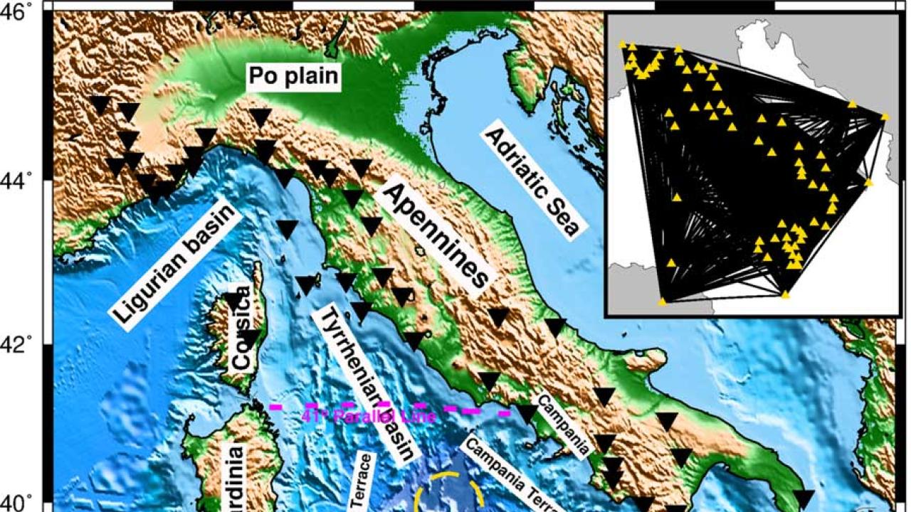
To the west of the boot of Italy, north of Sicily but east of Sardinia, lies the Tyrrhenian Sea. Below it, more known to geophysicists and deep sea creatures than anyone else, is the Tyrrhenian Basin, a patch of the Earth’s crust that is the subject of a new paper by not one but four geophysicists with ICTP connections. Not much was known about the very top levels of the Earth’s crust and mantle here, a knowledge gap that the ICTP team sought to rectify. In a paper published today in Scientific Reports, they have done just that.
“The Tyrrhenian Basin is right where the Eurasian plate and the African plate are running into each other,” says Daniel Manu-Marfo, the lead author on the paper and a former ICTP Diploma Programme student in Earth System Physics. The Tyrrhenian Basin is what’s known as a back-arc basin, a phenomenon common where one plate dives beneath the other one. “You’d expect compression where these two tectonic plates come together, but there’s also extension,” says Manu-Marfo. “The Tyrrhenian Basin has a major role in the geodynamics of the whole area.”
Manu-Marfo is now a joint PhD student between ICTP and the University of Trieste, working with ICTP geophysicist Karim Aoudia. For this paper, they were joined by another former ICTP Diploma Programme student as well as former ICTP postdoctoral associate, Surya Pachhai, as well as Radia Kherchouche, a sandwich PhD student between ICTP and the University of Science and Technology Houari Boumediene in Algeria. “This paper grew out of my Diploma Programme thesis, when I first started working with Karim,” says Manu-Marfo.
The paper investigates the structure of the crust and uppermost mantle, the part of the Earth called the lithosphere, and the boundary between these two layers called the Moho. The topography of the Moho is not well mapped, especially underwater regions, and the shape of the Moho can be used to tell a lot about past and future crust and mantle dynamics. “This is the highest resolution look ever at the lithosphere beneath the Mediterranean sea,” says Aoudia. “Daniel did a tremendous amount of great work to get to this incredible resolution power.”
Seismologists and geophysicists often use seismic waves to “image” the inside of the Earth, waves of energy that travel through the mantle and crust and are transformed by the density of what they travel through. Geophysicists use seismometers to measure those waves, which commonly come from earthquakes, to get a picture of what’s going on inside the Earth. But seismic waves coming from a long way away rarely reveal much about the upper layers near a seismometer, not to mention there is a dearth of seismographs on the floor of the Mediterranean. To get around these challenges when looking at the Tyrrhenian Basin, the team used a technique called Ambient Noise Tomography, drawing data from many, many tiny seismic waves and comparing how they registered on multiple nearby seismographs. “We used pretty much everything but waves caused by earthquakes,” says Manu-Marfo. The team used four years of data to put this picture together, down to a depth of 100 km below the planet’s surface.
“This is basically a snapshot what’s happening now in the lithosphere of the Tyrrhenian Basin,” says Aoudia. And what does that snapshot show? “There’s evidence of low velocity material underneath the basin”, at about 40-80 kilometers down, says Aoudia. “Previous work really only looked at much lower depths,” says Manu-Marfo. “This reservoir of low velocity material was pretty unexpected. There are a lot of potential reasons for low velocities in the upper mantle, magma could be bubbling up from the lower mantle,” something that needs more investigating. To Aoudia, it’s likely evidence left by the roll back of the Calabrian Arc, a chain of undersea mountains pushed back from Sardinia up to Calabria.
“One of the other surprising results of this work is how the mantle is right up near the surface here,” says Aoudia. The Tyrrhenian Basin is home to two massive underwater volcanos, Vavilov and Marsili, and under them the mantle is only about few kilometers away from the surface, one of the shallowest occurrences on the globe. This new evidence shows how drastically the mantle has exhumed, or risen, especially around Vavilov. This further colors in a picture of complicated crust-mantle dynamics in these types of back-arc basin regions.
“This paper bridges work done on the top 20 kilometers and work that looks much deeper, up to 600 kilometers down but with less resolution,” says Aoudia. “The map of the Moho in the Tyrrhenian Basin is completely new, and it’s such a high resolution map too.” This small region of the world worked as a laboratory for studying back-arc basins, for studying the jostling of tectonic plates in the region, for studying structures deep beneath our feet. Four ICTP scientists put together an intriguing picture of the structure of the crust and upper mantle, opening up many more questions.
----- Kelsey Calhoun